
(December 2017, Hardie Grant Travel, $24.95, poster, 950mm x 1350mm, 9781741175578)
BUY
See also World: Illustrated Map and Australia Map Puzzle
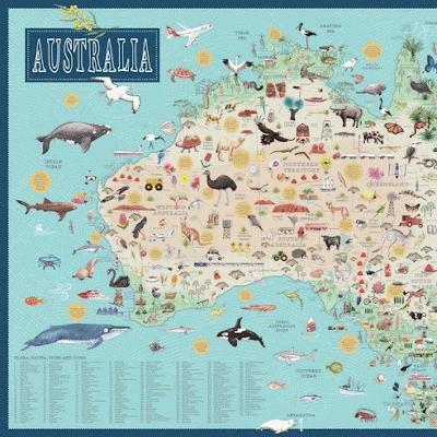
For curious adventurers who never stop exploring, this stunning, large-format map is a modern take on exploring Australia from coast to coast, from the highest mountain to the deepest surrounding sea. Depicting flora, fauna, natural wonders, sites and sights, over 250 labels are included, along with a key for shipwreck and Aboriginal rock art sites.
Wall maps are one of the latest trends when it comes to interior decorating, and now both adults and kids alike can adorn their wall with this beautifully illustrated map of Australia. Showcasing more than 300 illustrations of flora, fauna, landmarks, attractions and other Australiana, the detail on this map could keep anyone enthralled for hours. Fact bubbles, and keys for shipwrecks and Indigenous rock-art sites, will also help you learn more about this country.
Wall maps are one of the latest trends when it comes to interior decorating, and now both adults and kids alike can adorn their wall with this beautifully illustrated map of Australia. Showcasing more than 300 illustrations of flora, fauna, landmarks, attractions and other Australiana, the detail on this map could keep anyone enthralled for hours. Fact bubbles, and keys for shipwrecks and Indigenous rock-art sites, will also help you learn more about this country.
Watercolour illustrations combine with digital art to create an eye-boggling journey of our great land. This is a priceless resource for schools, libraries and organisations, and would make a striking piece of artwork for any child's (or adult's!) room.
FOOTNOTE: People often ask me about framing this map. Officeworks have laminators large enough (I know!) or you could try justframekits.com.au. They offer really affordable custom frames using perspex and super light aluminium frames. This map is enormous, so having light framing is ideal.
FOOTNOTE: People often ask me about framing this map. Officeworks have laminators large enough (I know!) or you could try justframekits.com.au. They offer really affordable custom frames using perspex and super light aluminium frames. This map is enormous, so having light framing is ideal.